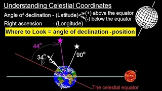
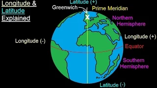
Circles of latitude

Latitude

In geography, latitude is a coordinate that specifies the north–south position of a point on the surface of the Earth or another celestial body. Latitude is given as an angle that ranges from –90° at the south pole to 90° at the north pole, with 0° at the Equator. Lines of constant latitude, or parallels, run east–west as circles parallel to the equator. Latitude and longitude are used together as a coordinate pair to specify a location on the surface of the Earth. On its own, the term "latitude" normally refers to the geodetic latitude as defined below. Briefly, the geodetic latitude of a point is the angle formed between the vector perpendicular (or normal) to the ellipsoidal surface from the point, and the plane of the equator. (Wikipedia).

Latitude
Video thumbnail

Geometry of the Earth (3 of 3: Measuring latitude & longitude)

More resources available at www.misterwootube.com

From playlist Working with Time

Video thumbnail

How to determine the reference angle of an angle in degrees

👉 Learn how to find the reference angle of a given angle. The reference angle is the acute angle formed by the terminal side of an angle and the x-axis. To find the reference angle, we determine the quadrant on which the given angle lies and use the reference angle formula for the quadrant

From playlist Find the Reference Angle

Video thumbnail

Astronomy - Ch. 2: Understanding the Night Sky (8 of 23) Understanding Celestial Coordinates

Visit http://ilectureonline.com for more math and science lectures! In this video I will explain the coordinates of the celestial sphere.

From playlist ASTRONOMY 2 THE NIGHT SKY

Video thumbnail

Find the reference angle of a angle larger than 2pi

👉 Learn how to find the reference angle of a given angle. The reference angle is the acute angle formed by the terminal side of an angle and the x-axis. To find the reference angle, we determine the quadrant on which the given angle lies and use the reference angle formula for the quadrant

From playlist Find the Reference Angle

Video thumbnail

How to find the reference angle of an angle larger than 2pi

👉 Learn how to find the reference angle of a given angle. The reference angle is the acute angle formed by the terminal side of an angle and the x-axis. To find the reference angle, we determine the quadrant on which the given angle lies and use the reference angle formula for the quadrant

From playlist Find the Reference Angle

Video thumbnail

Astronomy - Ch. 2: Understanding the Night Sky (7 of 23) Understanding Earth's Longitude & Latitude

Visit http://ilectureonline.com for more math and science lectures! In this video I will explain the Earth's longitude and latitude.

From playlist ASTRONOMY 2 THE NIGHT SKY

Video thumbnail

Learn how to determine the reference angle of an angle in terms of pi

👉 Learn how to find the reference angle of a given angle. The reference angle is the acute angle formed by the terminal side of an angle and the x-axis. To find the reference angle, we determine the quadrant on which the given angle lies and use the reference angle formula for the quadrant

From playlist Find the Reference Angle

Video thumbnail

Finding the reference angle of an angle in quadrant two

👉 Learn how to find the reference angle of a given angle. The reference angle is the acute angle formed by the terminal side of an angle and the x-axis. To find the reference angle, we determine the quadrant on which the given angle lies and use the reference angle formula for the quadrant

From playlist Find the Reference Angle

Video thumbnail

Geodetic Coordinates: Computing Latitude and Longitude

In this video we show how to compute the geodetic latitude and terrestrial longitude if given the velocity north and east. This is useful for simulating a body moving over a spheroid Earth model. Topics and timestamps: 0:00 – Introduction 0:10 – Terrestrial longitude, geodetic latitude,

From playlist Flight Mechanics

Video thumbnail

Understand Latitude and Longitude (How It Changed The World)

Latitude and longitude changed the course of human history. This video will explain the basic concepts of latitude and longitude and why the discovery of longitude changed the world.

From playlist Science Videos

Video thumbnail

14. Dataset tutorial with Pandas 👽(UFO example)👽

Most scientists and engineers are very familiar with Microsoft Excel for managing tabular datasets like comma separated values (.csv). However, excel is very limited in what it can do and does not do well with large datasets either. Instead, engineers should learn to work with the Pandas l

From playlist Intro to Python Programming for Materials Engineers

Video thumbnail

Android Development for Beginners 14

Get the Blocks & App Here : http://goo.gl/AUAx7g Best Android Book : http://goo.gl/uPhXFI In this video I completely finish the Android weather app. I show how to make App Inventor wait for an operation to complete before proceeding. We also will allow the user to pull up latitude and lo

From playlist Android Development for Beginners

Video thumbnail

Coding Challenge #57: Mapping Earthquake Data

In this Coding Challenge, I visualize earthquake data from the USGS by mapping the latitude, longitude and the magnitude of earthquakes with p5.js. The map imagery is pulled from mapbox.js and the math demonstrated coverts latitude, longitude to x,y via Web Mercator. 💻Challenge: https://t

From playlist 10: Working with data - p5.js Tutorial

Video thumbnail

Creating a Scatter Plot and Graphing a Line of Best Fit on the TI-Nspire CX // [LINEAR REGRESSION]

Today's Math Minute is devoted to a tutorial on how to use the TI-Nspire CX platform to graph a scatterplot and then identify the line of best fit (or linear regression). The data I used for the example can be found here as an Excel file: https://bit.ly/nolatandtempXLS; or here as a PDF: h

From playlist Math Minutes

Video thumbnail

How to Make Android Apps 24

Get the Code Here : http://goo.gl/XDoBGx In this part of my Android tutorial I'll cover many questions brought up after my last Android Google Maps tutorial. This time I'll cover how to set numerous markers, how to get latitude and longitude data and how to call for a Google Map that show

From playlist How to Make Android Apps

Video thumbnail

Coding Challenge #25: Spherical Geometry

In this coding challenge, I create a sphere in Processing using spherical coordinates and triangle strips. This is the 3rd part of a multi-part series on superformulas, superellipses and supershapes. Code: https://thecodingtrain.com/challenges/25-spherical-geometry 🕹️ p5.js Web Editor Ske

From playlist Coding Challenges

Video thumbnail

How To Create Crime Incident Web App In C# | Session 05 | #webapp | #programming

Don’t forget to subscribe! In this tutorial, you will learn to create a crime incident reporting web app in C#. ​​Through this series, we are going to look at the Crimeometer API and create a crime aware app out of it by calling its API functions This project would teach you how to cal

From playlist Create Crime Incident Web App In C#

Video thumbnail

Sketch the angle then find the reference angle

👉 Learn how to find the reference angle of a given angle. The reference angle is the acute angle formed by the terminal side of an angle and the x-axis. To find the reference angle, we determine the quadrant on which the given angle lies and use the reference angle formula for the quadrant

From playlist Find the Reference Angle

Video thumbnail

Rasa Livecoding: Re-training the dialect classifier (Part 2)

Welcome to Rasa livecoding with Rachael! This week we'll be continuing to work on retraining our dialect classifier now that our label encoding has been fixed. What's livecoding? It's folks working on real projects in real time with help from you, the audience! Expect some bugs, breakthr

From playlist Live Coding

Related pages

Orders of magnitude (length) | Circle of latitude | South | Ellipse | Coordinate system | Cross section (geometry) | Horse latitudes | Fixed-point iteration | Ellipsoid | Conformal map | Nautical mile | Flattening | North | Normal (geometry) | Gudermannian function | Colatitude | Degree (angle) | Tropic of Capricorn | Spherical coordinate system | Maxima (software) | Sphere | Cardinal direction | Arcminute | Great-circle distance | Vincenty's formulae | Declination | Antarctic Circle | Sexagesimal | Equator | Axial tilt | Tropic of Cancer | Theodolite | Arctic Circle | Oblate spheroidal coordinates | Newton's method | Isaac Newton